SOILx is a database of soil sites. It displays groups or subgroups of them on an interactive map. Individual sites can be accessed either from the map or a list.
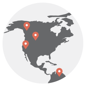
To view a map of all SOILx sites, navigate to the Map page. This page displays a Google map of all soil sites in the database. Individual sites are shown as clickable points on the map. The map automatically starts by displaying all soil sites, but you can drag it around or zoom in to view clustered or individual points.
To access an individual site, click on one of the pins. A popup window will appear with some basic information for that site. Click the “More details” link at the bottom of the popup window and you’ll be taken to the individual soil site page. All sites are also listed below the map.
You can also filter the sites on the map by Soil type by selecting the appropriate “Quick Filter” drop down menu(s) at the top of the map, and then clicking the “Search” button.
Contributing new soil sites
SOILx is a platform for soil data from almost any source. If you have good quality data for soil sites that you would like to contribute to SOILx, download this Excel file:
Please fill the fields in the template for your soil sites according to the guidelines included the spreadsheet. You must fill out the required fields in order for the site to be added to the database: Site Name, Latitude, and Longitude. All other fields are optional, but be careful – leaving fields blank may make it harder for learners to find your site. Please include as much verified detail as possible.
If you want to embed a YouTube video, please follow the supplied URL format precisely or the video won’t display. If you want to embed your own images (or those for which you have copyright) or link to a pdf file, you can either put the URL at which you host them into the appropriate column(s) in the Excel file or you can email them with the file to Dr. Maja Krzic (maja.krzic@ubc.ca).

This work is licensed under a Creative Commons Attribution-NonCommercial-ShareAlike 4.0 International License.